Navigation
Install the app
How to install the app on iOS
Follow along with the video below to see how to install our site as a web app on your home screen.

Note: This feature currently requires accessing the site using the built-in Safari browser.
More options
You are using an out of date browser. It may not display this or other websites correctly.
You should upgrade or use an alternative browser.
You should upgrade or use an alternative browser.
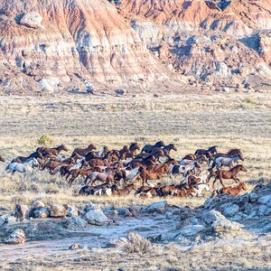
Down on the Farm
- Thread starter Ysarex
- Start date
- Joined
- Mar 29, 2016
- Messages
- 14,820
- Reaction score
- 8,264
- Can others edit my Photos
- Photos NOT OK to edit
OP
OP
Ysarex
Been spending a lot of time on here!
- Joined
- Nov 27, 2011
- Messages
- 7,136
- Reaction score
- 3,686
- Location
- St. Louis
- Can others edit my Photos
- Photos OK to edit
@Ysarex I've driven that levee many times from Cape Girardeau, north to Grand Tower, IL, and south, down to Thebes, IL. Made a few water trips from Cape To Cairo also, during my college days. Where was this taken?
I'm driving the Birds Point levee and I picked it up on the MO side at the Cairo bridge (hghwy 62) and headed south to New Madrid: Don't Mess with Mother Nature
I'd say this was about 1/3 of the way down. Everything I'm seeing from the top of the levee was inundated in 2011 when the Corp. decided to pull the plug on the Birds Point levee -- in part explains the new equipment shed.
Joe
P.S. What were you up to in the area?
- Joined
- Mar 29, 2016
- Messages
- 14,820
- Reaction score
- 8,264
- Can others edit my Photos
- Photos NOT OK to edit
OP
OP
Ysarex
Been spending a lot of time on here!
- Joined
- Nov 27, 2011
- Messages
- 7,136
- Reaction score
- 3,686
- Location
- St. Louis
- Can others edit my Photos
- Photos OK to edit
@Ysarex grew up in the area. Own a farm 50 miles NW of New Madrid, another in southern IL. In my youth spent a lot of time on or along the river fishing, hunting, on the MO side and gambling, partying on the IL side. Wonder I survived because back then it was a rough place to be without friends.
I moved to Saint Louis in my mid 20s. I took a shine to the river, but when my son was growing up I increased my interest and activity deciding to use the river as a focal point for raising the boy. We eventually canoed 1600 miles of it and boated all of it from top to bottom. He's in St. Paul MN now and I still hang around on the levee.
Joe
- Joined
- Mar 29, 2016
- Messages
- 14,820
- Reaction score
- 8,264
- Can others edit my Photos
- Photos NOT OK to edit
I moved to Saint Louis in my mid 20s
I moved south in 80, looking for a change of scenery.
Gary A.
Been spending a lot of time on here!
- Joined
- Sep 17, 2014
- Messages
- 22,357
- Reaction score
- 7,540
- Location
- Southern California
- Website
- www.garyayala.com
Your image of this trip say B&W to me.
- Joined
- Mar 29, 2016
- Messages
- 14,820
- Reaction score
- 8,264
- Can others edit my Photos
- Photos NOT OK to edit
I'm driving the Birds Point levee
Bad deal for farmers in 2011. The Corp put 130,000 acres of productive tax paying land out of production to save a few acres of blighted abandoned buildings in Cairo. If you want urban decay shots, drive through there. Buildings empty and decaying, grass and weeds growing up through cracks in the streets.
OP
OP
Ysarex
Been spending a lot of time on here!
- Joined
- Nov 27, 2011
- Messages
- 7,136
- Reaction score
- 3,686
- Location
- St. Louis
- Can others edit my Photos
- Photos OK to edit
I'm driving the Birds Point levee
Bad deal for farmers in 2011. The Corp put 130,000 acres of productive tax paying land out of production to save a few acres of blighted abandoned buildings in Cairo. If you want urban decay shots, drive through there. Buildings empty and decaying, grass and weeds growing up through cracks in the streets.
I've seen Cairo -- it's pitiful. Cairo was always a mistake. I expect to live long enough to see the river take it back.
Joe
Gary A.
Been spending a lot of time on here!
- Joined
- Sep 17, 2014
- Messages
- 22,357
- Reaction score
- 7,540
- Location
- Southern California
- Website
- www.garyayala.com
Timeless.
- Joined
- Mar 29, 2016
- Messages
- 14,820
- Reaction score
- 8,264
- Can others edit my Photos
- Photos NOT OK to edit
I'm driving the Birds Point levee
Bad deal for farmers in 2011. The Corp put 130,000 acres of productive tax paying land out of production to save a few acres of blighted abandoned buildings in Cairo. If you want urban decay shots, drive through there. Buildings empty and decaying, grass and weeds growing up through cracks in the streets.
I've seen Cairo -- it's pitiful. Cairo was always a mistake. I expect to live long enough to see the river take it back.
Joe
Been a few years since I drove through it. I remember how "stark and eerie" it was driving down Commercial Ave, with all the crumbling, abandoned buildings. When I was much younger, I remember seeing a Civil War hospital, but I can't remember if that was Cairo, or Mounds City, I think there was one at both. Are either still standing????
Did a scary walk there one night after dark. We had come down river from Cape Girardeau, and didn't bring enough fuel. Docked at the river front and went walking looking for gas. Finally found a gas station, and headed back up the river. Really did some dumb things in my youth.
OP
OP
Ysarex
Been spending a lot of time on here!
- Joined
- Nov 27, 2011
- Messages
- 7,136
- Reaction score
- 3,686
- Location
- St. Louis
- Can others edit my Photos
- Photos OK to edit
I'm driving the Birds Point levee
Bad deal for farmers in 2011. The Corp put 130,000 acres of productive tax paying land out of production to save a few acres of blighted abandoned buildings in Cairo. If you want urban decay shots, drive through there. Buildings empty and decaying, grass and weeds growing up through cracks in the streets.
I've seen Cairo -- it's pitiful. Cairo was always a mistake. I expect to live long enough to see the river take it back.
Joe
Been a few years since I drove through it. I remember how "stark and eerie" it was driving down Commercial Ave, with all the crumbling, abandoned buildings. When I was much younger, I remember seeing a Civil War hospital, but I can't remember if that was Cairo, or Mounds City, I think there was one at both. Are either still standing????
Did a scary walk there one night after dark. We had come down river from Cape Girardeau, and didn't bring enough fuel. Docked at the river front and went walking looking for gas. Finally found a gas station, and headed back up the river. Really did some dumb things in my youth.
Can't say I've seen an old Civil War Hospital. I was there last year driving through to TN. It's harder to get to now as they have the Ohio bridge closed for repairs. Cairo took a huge hit in the ice storm of 2010 -- bldgs. collapsed and roofs fell in and few had the resources to do anything so even now you can see the remains of that damage. If Bungee leaves it's over.
Joe
- Joined
- Mar 29, 2016
- Messages
- 14,820
- Reaction score
- 8,264
- Can others edit my Photos
- Photos NOT OK to edit
I was through there around 2010. Kind of lengthy but interesting read on the growth and demise of Cario, IL Cairo, Illinois - Death by Racism
Most reactions
-
 430
430 -
 286
286 -
 279
279 -
 265
265 -
 217
217 -
 189
189 -
 178
178 -
 176
176 -
 171
171 -
 165
165 -
 158
158 -
 130
130 -
 117
117 -
I
97
-
 94
94