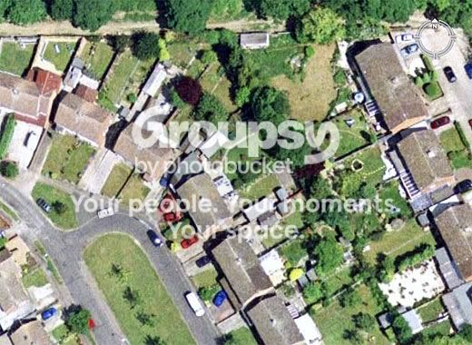
My house is right in the middle. The one with two red cars and a blue one out the front. I think it was taken about five years ago as we have none of those now. :shock:
I have been on a big saltwater flyfishing kick lately. Makes sense seeing as I get to do it once a year if I am lucky. But Google Earth is great because from the pictures you can see where the shallow water "flats" areas are in whatever area you are fishing.
The light green areas is where I want to fish. Dream spots show include Eleuthera, Bahamas and Turks and Caicos.
I like google earth too. But you can get something similar from weather.com. On the home page near half way down click where it says interactive map. You can zoom right down similar to google. Only difference you only get a overhead perspective. But on the plus side you can use the map to track storms anywhere in the US including thunderstorms and snowstorms. You can view anywhere on the earth but the weather details are only available for the US.
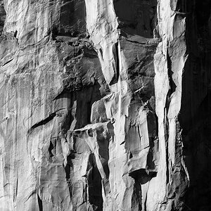
Google Maps has a hidden feature that allows anyone to zoom in extremely close on some satellite pictures. This screenshot shows the closest zoom available for a location in the Sahara desert. Using this hidden feature, you can zoom in a little closer in almost any Metropolitan area, and MUCH closer in select areas.
2. Zoom in as far as you can, and click “link to this page” at the top right
3. Now replace the “z” parameter in the URL with a higher value, e.g. 20, 22, or 23, and wait. Some locations will now show more detailed imagery
Google Maps has a hidden feature that allows anyone to zoom in extremely close on some satellite pictures. This screenshot shows the closest zoom available for a location in the Sahara desert. Using this hidden feature, you can zoom in a little closer in almost any Metropolitan area, and MUCH closer in select areas.


")


![[No title]](/data/xfmg/thumbnail/36/36396-f8e84def7352af726df923054b86284f.jpg?1619737549)
![[No title]](/data/xfmg/thumbnail/37/37636-e02c7efccb426a8951ed97a37c0f9307.jpg?1619738157)