Ysarex
Been spending a lot of time on here!
- Joined
- Nov 27, 2011
- Messages
- 7,456
- Reaction score
- 4,271
- Location
- St. Louis
- Can others edit my Photos
- Photos OK to edit
Got a chance for an overnight away and drove down into the Missouri Bootheel for some serious levee driving. The Mississippi river levees are all topped with a gravel road and to a large extent are publicly accessible. It's slow driving but you get to be alone (encountered 2 pick ups in 50 miles) and the view from the top can be charmingly bucolic. The levees are 60 feet high but that's 60 feet higher than everything else in the landscape.

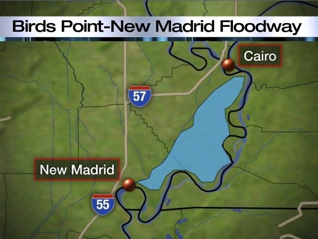
So I drove the outer Birds Point levee. I took this panorama right at the top of the levee just a few hundred yards from the fuse-plug (round the bend about center in the photo), which brings up the title of the post. Controlling flooding on the Mississippi River is a major case of messing with Mother Nature. After the 1927 flood Congress charged the Army Corp of Engineers with the task of fixing Mother Nature. The problem with levees of course is that the higher you build them up river the worse things get down river so the folks down river sneak up river at night during a flood and break holes in the up river levees.
The Birds Point levee really illustrates the problem. Cairo Ill. is across the river in a totally ridiculous location. No one in their right mind could ever think that the confluence point of two huge rivers that drain 40% of a country would be a great place to found a city. It would however appeal to the military mind as the strategic place to put a fort. Cairo as such was founded and re-founded a dozen or so times as the location of Fort Defiance. Eventually Cairo became a small city and the county seat surviving behind 60 foot levees. But the folks up river kept building higher and higher levees. So after 1927 the Corp came up with the Jadwin plan (Maj. Gen. Edgar Jadwin) to create release valve floodways as a last ditch solution to save critical locales like Cairo, Old River Control, and New Orleans.
Embedded vertically in the Birds Point levee are a bunch of huge plastic pipes they call the fuse-plug. When the levees surrounding Cairo reach a specified critical stage they fill the fuse-plug pipes with explosive and blow the Birds Point levee. This of course turns 130,000 acres of MO farmland into an instant 50 foot deep lake -- not too popular with the MO farmers.
Since the plans adoption this "explosive" option has been used twice -- 1937 and 2011. Some of you may remember hearing the news in 2011 about the choice to use both this floodway as well as the Morganza floodway further south.
Joe
Last edited:


